Rice Mountain
During the existence of the Town of Lansingburgh, Rice Mountain formed part of North Lansingburgh from at least 1819 (when part of the Town of Schaghticoke south of the Deep Kill was annexed) to 1901.
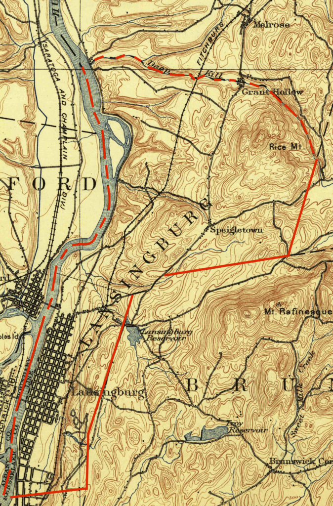
Detail of 1898 US Geological Survey map of Cohoes quadrangle with Town of Lansingburgh borders marked in red.
Rice Mountain is not public as it had apparently been for decades:
—If the weather be favorable the juniors of the Troy, Watervliet, Lansingburgh and Waterford Young Men’s Christian Associations will have a ramble to-morrow to Rice Mountain. The rendezvous is the Lansingburgh Association home, whence the young men will tramp to the objective point.
Troy Daily Times. April 20, 1900: 4? col 2.
Rensselaer County Rambles.
—
No. 21—Rice Mountain.
BY HI TRAYLES [Edward Thornton Heald].
Written for The Troy Times.
Rice Mountain is next to Bald Mountain, the closest and most accessible hill climb to Troy. It is 300 feet lower than Bald Mountain (925 compared with 1,227 feet), and only a third of the bulk of its sister hill. Yet it offers on its northern sides steeper and wilder slopes than are to be found anywhere on Bald Mountain. In spite of its smaller size it offers more variety and interest to the hill climber, and its summit is further in distance and higher in altitude from the nearest road than is the summit of Bald Mountain. The latter hill has a network of roads winding all over its flanks and crossing over the divide of its long crest, Rice Mountain, on the other hand, while surrounded by valley roads, is untouched by any road above the 500-foot level.
The view from Rice Mountain is practically the same as from Bald Mountain, except that the latter gives a better prospect into the Grafton hills.
Rice Mountain rises east of the main road to Schaghticoke, between Speigeltown and Grant’s Hollow. The southern slope is open and gradual and much easier to climb than the northern slopes, which are heavily timbered and in places too steep for safety in icy weather.
You can drive your auto to Speigeltown, seven miles from Troy, and leave it parked there while you make your hour and a half to two-hour walk to the top of the mountain and back.
As you park your car in Speigeltown, facing north, you are looking up the southern slopes of Rice Mountain. Directly ahead rises a cleared hump or knob. This makes a convenient first objective on the climb. Walk along the main road a quarter of a mile, past the church, to the point where the Thieves Hollow Road [Irish Road] starts to the Hudson. Opposite this stands an empty, unfinished building, which leaves you guessing whether it was intended for a garage, barn or house. Enter the field here and climb to the top of the knob. The climbing is slippery enough in icy weather. From the knob you begin to get fine panoramas over the Hudson valley, down to the Catskills and north to the Adirondacks, while southeastward the whole bulk of Bald Mountain presents its long snowy back. Below you lies the wooded ravine known as Thieves Hollow as it cuts its way down to the Hudson.
From this 500-foot knob you see another higher knob across the snow-covered fields and intervening ravines. This is 600 feet high and gives fine panoramas, and the first good view of the rest of Rice Mountain to its wooded, double-humped summit.
From this point you have the choice of several routes to the top, all open and easy. You could veer to the left and follow the ridge next to the woods, or follow up the little valley and creek that lies before you, or bend your course to the right to another little ridge 700 feet high. The latter gives the better views. You follow along this ridge a quarter of a mile enjoying the colorful winter pictures. If the day is gray, the panoramas are studies in blue, dark blue where timbered, bluish white over the open snow fields. The blues deepen in darkness with the distance. Sometimes the clouds melt into the Taconics or the Catskills so that the dividing line can hardly be distinguished. Again the mountains will seem to merge into the clouds and carry up into the high heavens.
At the northern end of this narrow 700-foot ridge, you drop down into the open headland of a little creek. About the fields stand a few large remnants of ancient forest monarchs. You come to the source of the creek, a cold spring 200 feet under the summit of the mountain. In summer this is a refreshing spot after a hot climb. In winter it afford a pretty picture flowing clear through its bed of ice and snow.
Another quarter mile climb brings you to the top. This is the steepest part of the climb, and while it is simple enough in summer, it can give some real difficulty in icy weather.
When you reach the top, you will find that it consists not of two humps, but of two little parallel ridges, divided by a shallow ravine. The ridges are almost identical in height, thought the geodetic survey mark is on the western ridge. The ridges are covered with short little hardwoods which however in winter time, interfere but little with the views. You now get views northward over Melrose and towards Schaghticoke. The other hills circling around to the reservoir are before you. Considerable patches of woods darken stretches of the hilly landscape. Before you the sides of Rice Mountain are heavily timbered and drop down steeply to the deep cut of Deepkill. You can just make out Grant’s Hollow, where Deepkill flows out from the base of the mountain.
If you had thought of passing on over the top, you will probably decide to wait until summer time, when snows will not hide your footing.
You can vary your return route by following through the woods a little ways in from the open fields. The timber is mostly hardwoods, among which are many fine white birches, mingled with some spruces and hemlocks.
You finally come out of the end of the woods, a short distance above the main Schaghticoke road. You can still avoid the farm houses by paralleling your course to the road, across the open fields, and through groves of reforestation pines, where the little creek comes down from the spring we saw just under the summit. You soon come in sight of the first knob we climbed. Here you can drop over to the road, half a mile from Spiegletown. This walk is about four miles in all.
Troy Times. March 21, 1927: 9 cols 3-5.
See also Heald, Edward T. Taconic Trails: Being a Partial Guide of Rensselaer County Rambles by Auto and Afoot. Albany, NY: J. B. Lyon Co., 1929. 16-19. https://babel.hathitrust.org/cgi/pt?id=wu.89067607952;view=1up;seq=38